Shift Coastal Technologies
Steering Maritime Data Into The Future

Empowering our clients to close the gap between data and action.
Shift Coastal Technologies develops IoT-enabled autonomous platforms for enhanced decision-making
CUSTOMER DRIVEN PRODUCTS & SERVICES
MODULAR & UPGRADEABLE TECHNOLOGY STACK
INDIGENOUS JOINT VENTURES
Shift Coastal Technologies Solutions (Powered by CiMS®):
MARINE INCIDENT RESPONSE
Powered by CiMS®
DEFENSE & SECURITY
Powered by CiMS®
MARINE CONSERVATION & PROTECTION
Powered by CiMS®
MARINE INFRASTRUCTURE
Powered by CiMS®
Trusted by:

OCEANSLED®
Autonomous Surface Vessels To Elevate Your Operations
The OceanSled® series is tailored for high-risk near shore operations designed as multi-mission un-crewed surface vessel (USV) capable of carrying a wide variety of payloads and sensor rich technologies for maritime tasking.
INTEGRATIONS
Elevate Your Operations With High-Quality Data
Our integrations are equipped with sensors to swiftly gather high-quality data for a rapid understanding of incidents. Featuring a visual-spectrum camera, an infrared camera, air quality monitoring sensors, and a water sampling kit, our integrations deliver diverse data types to enhance response operations.


OCEANSLED® REMOTE OPERATIONS CONTROLLER (OS-ROC)
Advanced Connectivity and Efficient Communication
Maximize the capabilities of the OceanSled® with the Field Operations Controller. Featuring a robust onboard computer and up to three large screens for optimal control efficiency and incident support. In smaller incidents, the Controller can transform into the Incident Command Post, utilizing one screen for the Common Operating Picture to showcase all assets and shipping movement in the area. The Centre receives and can transmit all CiMS hardware data to the cloud if necessary.
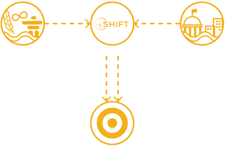
We Bridge the Gap
The Indigenous–Industry–Government Ecosystem
Our business is composed of vertically integrated IoT enabled products coupled with professional services that are powered by our customer needs and refined through our indigenous partners and collaborative win-win-win Indigenous – Industry – Government ecosystem.
Creating Positive Change from Coast to Coast
TECHNOLOGY COMPANIES PARTNERING WITH INDIGENOUS
FULL TIME JOB OPPORTUNITIES CREATED
TECH TRAINING HRS FOR COMMUNITY MEMBERS
GOVERNMENT PARTNERS
Creating Positive Change Along the Coast
TECHNOLOGY COMPANIES PARTNERING WITH INDIGENOUS
FULL TIME JOB OPPORTUNITIES CREATED
TECH TRAINING HRS FOR COMMUNITY MEMBERS
GOVERNMENT PARTNERS
Upgrade Your Operations
Enhance your maritime decisions with intelligent data.
Communities & Organizations We Work With